Old Mill Loop
- Glenbarrow Car Park, Rosenallis, Co. Laois
- Download Map (PDF)
- Listed in Loop Walks, Glenbarrow
- Distance: 10.5 km / 2.5 -3 hours
- Services: Clonaslee (7km), Rosenallis (5km)
- Trail Grade: Strenuous
- To suit: Higher than average fitness levels
- Terrain: Forestry trails, riverside walk
- Min. gear: Walking boots, fluids, snacks, hiking clothing
- Trail maintenance: hikeit@slievebloom.ie
- Dogs allowed: No
Trail Directions
Start from the trailhead at Glenbarrow car park and follow the red arrows onto a downhill track and enter Glenbarrow Woods via wooden railings.
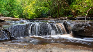
Continue along this path upriver for about 800m. Here, by the river, the stone floor of the valley is exposed. Follow the path up river and you come to the Glenbarrow Falls. Follow the path past the waterfall for approximately 800m. The path splits on a bend - continue following the red arrows along river bank, for approximately 2km, to the ruins of an old mill. Leaving the mill behind, follow the riverbank for another short distance before turning uphill (left) and join the forestry road, turn right here. Follow the forestry road for 300m before turning left uphill past ruins of Clear’s old house. Follow red arrows to Bog Bridge leading down to the Ridge of Capard Viewing Point.
Continue downhill to Ridge of Capard car park. Turn right here and continue downhill on the tarred road joining the Eco walk and on third bend, turn left into Capard wood. Follow the trail through the wood and join up with forest road. Follow red and orange arrows along forest road until you reach 3-way junction. Enter the Bog Bridge here and follow the trail downhill through mixed woodland to a forest barrier. Turn right here, and enjoy the last 200m back to the trailhead at Glenbarrow car park.
Directions to Glenbarrow trailhead
Rosenallis on the R422 between Clonaslee and Mountmellick. On the sharp bend follow the signpost for Glenbarrow L2018. After 2km straight to next junction. After 2.5km turn right at a follow the signs to the Ridge of Capard (Grid Reference N 364 064
In 2007, a series of looped walks were developed at various trailheads in the region following a mix of forest tracks, riverbanks, old roadways, and grassy trails. There are a few rough and rugged sections - but they rarely rise to high altitude and do not demand great stamina. This loop is one of three which start and finish at the Glenbarrow trailhead - key features include the bank of the spectacular River Barrow, a 3-tiered waterfall, the ruins of an old water mill, and broadleaf woodlands that, in late spring, are ablaze with bluebells.