Glenbarrow Eco Walk
- Glenbarrow Car Park, Rosenallis, Co. Laois
- Download Map (PDF)
- Listed in Loop Walks, Glenbarrow, Eco Walks
- Distance: 8.5km / 3 hours
- Services: Clonaslee (7km), Rosenallis (5km)
- Trail Grade: Strenuous
- To suit: Higher than average fitness levels
- Terrain: Forest trails & roads
- Min. gear: Walking boots, fluids, snacks, hiking clothing
- Trail maintenance: hikeit@slievebloom.ie
- Dogs allowed: No
Trail Directions
The trailhead is Glenbarrow carpark. Follow Orange arrows onto a downhill track. Enter Glenbarrow woods via wooden railings.
Continue along this path upriver for about 800m. Here by the river, the stone floor of the valley is exposed(1). Follow the path upriver and pass the Clamphole Falls (2). Continue on path past waterfall following orange arrows upstream to Barrow Gorge (3). Remain on river bank until reaching the ruins of old homestead (4) on left. Turn left here and follow orange arrows around ruins onto old track. This leads uphill to Ridge of Capard Car Park (5).
From the car park, follow orange arrows up along Bog Bridge to viewing point. From here continue on Bog Bridge to old mountain track (6). Turn left downhill which leads onto tarred road. At the 3rd bend downhill enter Capard Wood (7) on left. Follow orange arrows through wood until reaching forestry road.
Pass old stone Quarry (8) on left. This section was part of the old Capard Estate (9) which includes old broadleaf woodlands on left. At forestry road junction follow orange arrows onto Bog Bridge (10) and continue on Bog Bridge downhill through woodland to forestry road and barrier. Turn right here back to trailhead.
Directions to Glenbarrow trailhead
Start from the village of Rosenallis on the R422 between Clonaslee and Mountmellick. On the sharp bend follow the signpost for route to Glenbarrow L2018. After 1.8 km take a right turn at a junction. After 2 km turn left at a crossroads. Note: the trailhead is signposted from Rosenallis (and Clonaslee).
Nature Notes
If you are visiting in the autumn especially, it is worth while turning aside into the dark spruce woods, because although the absence of light excludes green plants, the woodland floor carries a rich and diverse fungus flora. Among the common species you may find under the spruce is the saffron milk-cap Lactarius deliciosus, an edible species easily recognized by its orange colour, becoming greenish with age, and its unmistakable carrot-coloured ‘sap.’ Another common edible species is the blusher Amanita rubescens, but this can easily be confused with a number of poisonous species and is best avoided. If you are with a less than normally noisy group, you may hear the high-pitched notes of the goldcrests in the tops of the conifers announcing your arrival. Remember you are likely to encounter few large animals on your walk, because they can generally get out of your way swiftly and quietly unless you are in a small or unusually silent group!
To your left you may notice an older track here and there. This is what remains of the old mountain road that was the way into Glenbarrow in earlier times. It was used to carry out the stone from its quarries. One of the biggest of these quarries was along this stretch of the river and wood.
As you walk upstream along the path you will encounter a great variety of woodland plants. Most of them flower in spring, before the trees get their canopy of leaves. This is the best time to look for bluebell, wood avens, wood sorrel, wood sanicle, wood anemone, primrose, ramsons or wild garlic, dog violet and a great many more of the characteristic plants of broadleaved woodland.
The Walk
Stop 1 – In the bed of the River Barrow: the Old Red Sandstone and the end of the Ice Age
This is one of the best places to examine the character of the rocks that make up the Old Red Sandstone series in Slieve Bloom. The bed of the river here is a natural pavement of sandstone, but although the rock itself is natural the pavement is actually the floor of an old quarry from which stone was taken in the 19th century. If you look carefully over the pavement you will find some of the small round holes drilled for the insertion of explosive, and on the face of the little cliff on the right bank of the river just down from the hut you can see initials carved there by stone cutters. (if you wander into the wood just downstream of this point you can see what remains of the old quarry workings).
The sandstones originated as sandbars in the channel of a great river at the end of the Devonian period of earth history about 354 million years ago. Fine-grained mudrocks occur with the sandstones (we will see them upriver at the waterfall). These formed on the floodplain beside the ancient river during periods when it was in flood and mud and silt were carried across the floodplain by the swollen waters. In addition to sandstones and mudrocks, conglomerates are occasionally met with. These originated as river gravels in the bed of the late Devonian river.
One of the dominant features of the landscape just here (and all the way up Glenbarrow) is the high cliff across the river, which has been colonized in many places by birch and willow. This is glacial moraine, a mass of boulders, clay and rock debris, much of it calcareous or limy, dumped by a melting glacier which could no longer surmount the barrier of Slieve Bloom that stood in its path at the very end of the Ice Age 10,000 years ago. The presence of this lime accounts for the presence of many calcicole or lime-loving plants here: including scented orchid, butterwort, grass of Parnassus, carline thistle, blue fleabane, burnet rose, shrubby hawkweed, greater hawkbit, knotted pearlwort and many more. If your visit is not in winter you will see forests of giant horsetail.
Here you will see a fine example of a till stone: a limestone boulder that was scratched and striated all over its surface by neighbouring rocks as they ground their way slowly forward in the entombing ice.
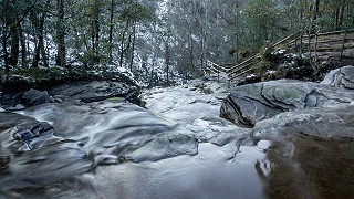
Stop 2 – Waterfalls on the Barrow
Now make your way upstream from the rock pavement to the waterfall at Stop 2. If you stand beside the plunge pool at the foot of the main waterfall you will notice that the lip of the waterfall and the rock at the falls above are of sandstone: but the rock under the waterfall is a much softer, reddish-coloured mudrock. This mudrock is very easily eroded (you can pick it away even with your hand). This is part of the explanation of how the waterfalls here started in the first place. Potholes are forming under the upper falls, and in the area between the falls are examples of fossil potholes, marking an earlier position of the upper plunge pool.
Stop 3 – Bridge Across the Barrow Gorge
Above the waterfall the river has cut a small gorge for itself through the sandstone. This stretch of the river has been little disturbed for thousands of years and retains much of its natural character and biological diversity. Many of the trees are native sessile oak, though some show signs of hybridization with lowland pedunculate stock. Mountain ash and holly are especially characteristic, and there are occasional whitebeam and aspen. The dominant trees however are the birch and willow that are so well adapted to the generally wet conditions. The ground flora in these gullies tends to be dominated in steeper areas by great woodrush, but most of the colourful plants of broadleaved woodland occur where conditions are suitable: including bluebell, wood sorrel and woodruff. Among the rarer species are marsh hawksbeard and Welsh poppy.
Just upstream of here (where the tributary stream joins the main river) is the site of what appears on the first edition of the Ordnance Survey six-inch map as the ‘Hermit’s Cell’: but all memory and tradition of who this hermit was has been lost.
Stop 4 – The Glenbarrow Homestead
If you continue across the tributary on the Upper Glenbarrow spur you will follow a track that continues to run parallel to the river . This takes you to the ruins of a 19th century farmstead.
It is hard to believe as you stand among these ruins in the middle of the forest that at one time this was a prosperous farmstead, and what a spectacular location it must have been! Can you imagine what the views must have been like at that time, the utter isolation?
You can trace the outlines not only of the house and outbuildings, but of the stalls where the cattle were tethered.
Look at the situation of the farmstead on the old Ordnance Survey map, which was made in the 1830s, before the Great Famine, to see what this part of Slieve Bloom looked like 170 years ago.
Stop 5 – The Ridge of Capard
From the rear of the old farmstead you follow orange arrows on original old track to the Ridge of Capard. On reaching car park follow orange arrow to your right on to boardwalk up to viewing point. The vegetation has now taken on the character of heathy wet grassland, characterized by such species as tormentil, heath bedstraw, lousewort, lesser spearwort and heath speedwell. Butterwort and heath spotted orchid are locally abundant.
If it is June keep an eye out for the small, hairy black caterpillars of the emperor moth on heather. Later in the summer, after they have moulted several times, they will be spectacular green creatures with startling pink blobs haloed in black.
Then cross the heather-clad ridge southward before turning left onto an old mountain track that brings you back down to join the main road. This track is an old turf road: a relic of the days when one of the most valued resources of the mountain was the turf that provided everybody with their year’s supply of fuel. In early summer a hundred years ago this would have been a very busy place, with people travelling up ‘to save the turf’ and ass-drawn carts coming and going as long as the light lasted.
Stop 6 – Wild fruit and butterflies
The Ridge is at its most splendid in July and August, when the heather is in purple bloom. In late summer and early autumn the hedges along the track leading down to the road are full of bilberries and wild raspberries, and (a little later) blackberries. Notice the way centuries of erosion by the wheels of the carts and accompanying boots have eroded the level of the track so that it often lies well below that of the surrounding bog.
This is an excellent stretch for butterflies: red admiral, painted lady, silver-washed fritillary, small tortoiseshell, ringlet, meadow brown and large white are all common.
The walk now follows the main road downhill. As you walk along look at the old walls as the side of the road. You will notice that they are white in colour and on closer inspection you will see they are covered with a warty-coloured growth. This is a special lichen called parelle, which grows on sandstone. The true colour of these rocks is the same as those you saw in the river bed earlier.
Stop 7 – Capard Wood
At the third bend downhill the path enters Capard Wood, an old broadleaved estate forest of oak and beech, now managed by Coillte for its biodiversity value. This is a magical place, utterly spectacular in May, when its vast carpet of bluebells is in flower. There are lots of interesting fungi in late summer and autumn especially, including the stinkhorn.
The walk takes you up through the wood and then across into a smaller area of conifer woodland before emerging onto another forest road that takes you back up the ridge again.
Stop 8 – The Quarry: a window into a vanished world
Just beyond the wood the track goes through a belt of alder, willow and rowan (with luxuriant tussock grass). Then you come to a quarry where stone is extracted for road-making. The rock here is Silurian in age: these are the rocks that lie beneath the Old Red Sandstone throughout Slieve Bloom: indeed, these are the rocks which constitute the mountains’ heart.
Geologically Slieve Bloom consists of a number of central ‘inliers’ of folded older rocks of Silurian age (443–417 millions of years ago) covered by a thinner blanket of less disturbed rocks which formed at the very end of the Devonian period (about 354 million years old; the Devonian ran from 417–354 millions of years ago). From the point of view of rock type and composition the Silurian rocks comprise alternating greywackes and siltstones. These sediments were laid down in the very deep water of the Iapetus ocean of Silurian times. They were transported into this deep water by turbidity currents. These are slurries of sand-laden muddy water behaving as a dense liquid, usually initiated by slumping off the continental slope. Such currents often start in submarine canyons at the present day, and are the principal agents of large-scale deep-water marine sedimentation. The resulting rocks are called turbidites.
Fossils that have been recovered from the Silurian rocks are used to work out their age, but fossils are very rare in these rocks because of their deep ocean origin. They are mostly things called graptolites, and they enable us to work out the age of the rocks. Graptolites are long extinct, but they were related to vertebrates. Why not see if you can find any of these enigmatic little fossils – but do remember: they are rare and they are very small, and they look like toothed black scribbles on the rock!
These Silurian sedimentary rocks were folded towards the end of the Silurian during the episode of earth movements known as the Caledonian Orogeny (which involved the collision of two of the earth’s crustal plates). As a result the originally horizontal beds now dip at often steep angles.
After the Silurian the new mountains (which were comparable to the Himalayas in the beginning) were worn down, eventually to a level plain. Later still, during the late Devonian, this became the site of the sands, silts and gravels that became the Old Red Sandstone we saw earlier. In contrast with the underlying Silurian, the Devonian rocks have only a gentle slope (dip), and are often horizontal.
At the end of the Devonian period, the warm, shallow seas of the Lower Carboniferous (which began 354 million years ago) encroached on and subsequently covered the whole area. These and all the younger rocks which covered them subsequently have since been completely eroded away from Slieve Bloom.
Stop 9 – Offaly’s Volcano: the view to Croghan Hill
If you look across the flat plain of Offaly at the foot of Slieve Bloom you will notice, away on the horizon to the north-east, a conical hill rising out of the plain. This is Croghan Hill, and although it is only 235 metres above sea level it dominates the landscape because the limestone plateau on all sides is so flat. It would have dominated the world in which it formed in a much more dramatic way though, because Croghan Hill is a volcano that rose out of the Carboniferous ocean – or at least it is the bit of that volcano that remains.
When it was active the Croghan Hill volcano would have been an imposing conical feature. Nor was it the only one: there were several subsidiary volcanic vents branching from it. Today these form the low hills that surround Croghan. When they first rose from the ocean floor, vast quantities of volcanic pumice poured from these volcanoes into the surrounding ocean, where it settled in due course as an ash on the limy bottom. Angular fragments of limestone and chert are sometimes found in the ash. These would have been blown out of the volcano when it exploded. But it also contains rounded pebbles and boulders which can only have formed on beaches around the volcanic islands formed by the several vents.
Later on, when its explosive power was spent, cooling lava plugged the vent, hardening in due course to basalt. Because basalt is so much more resistant to weathering than limestone, it forms the core of the hills today.
Stop 10 – Birchwood
As you approach the end of your walk, it is well worth time spending time in this little wood – especially in autumn when the fairy-tale red mushrooms with the white spots are abundant. This is the fly agaric Amanita muscaria, which gets its name because it was used at one time for keeping off flies. As well as being beautiful it is poisonous – and intensely hallucinogenic!